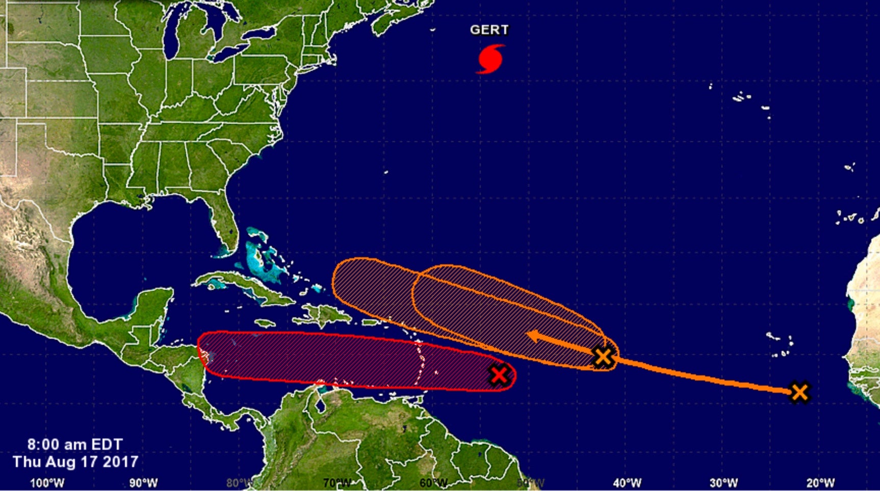
| Above: The National Hurricane Center outlined three areas across the Main Development Region of the tropical Atlantic in its five-day tropical weather outlook issued at 8:00 am EDT Thursday, August 17, 2017. The leftmost system, shown here in red, was designated Potential Tropical Cyclone 9 at 11 am EDT. Image credit: NHC. |
Late August is living up to its climatological reputation as a peak portion of the Atlantic hurricane season, with NHC issuing advisories for two systems--Hurricane Gert, south of Newfoundland, and Potential Tropical Cyclone Nine, poised to move through the Lesser Antilles Islands on Friday. NHC was also highlighting a medium chance of development for two other African tropical waves in the Atlantic Main Development Region (MDR) between the Lesser Antilles Islands and coast of Africa. Various models predict that either or both of these could develop into tropical cyclones early next week. The high level of activity is due, in part, to ocean temperatures in the tropical Atlantic that are about 0.5°C to 1°C above average for this time of year. Another factor is rising air and low pressure over the tropical Atlantic created by a phase of the Madden-Julian Oscillation (MJO) favorable for tropical cyclone formation, as mentioned by the Weather Company’s Michael Ventrice in a tweet earlier this week.
Even in late August, it is not common to get three simultaneous Atlantic tropical disturbances capable of developing into tropical cyclones. Since 2014, when NHC first began issuing its 5-day Tropical Weather Outlook, we could find only three occasions when they highlighted as many as three areas of concern in the Atlantic, and none of these cases had all three systems located in the MDR:
September 9 - 10, 2016
August 21 - 23, 2015
August 26 - 28, 2014
However, back on August 11, 2009, the 2-day Tropical Weather Outlook highlighted a tropical depression and two areas of concern in the MDR, and there may be other cases one can find in the 2009 – 2013 archives.
 |
| Figure 1. Visible-wavelength GOES-16 satellite image of Potential Tropical Cyclone 9 as of 1515Z (11:15 am EDT) Thursday, August 17, 2017. GOES-16 data are preliminary and non-operational. The RAMMB site also has a "floater" loop zoomed in on PTC 9, offering vivid detail. Image credit: RAMMB/CIRA @ CSU. |
Potential Tropical Cyclone 9 heading toward Caribbean
The NOAA/NWS National Hurricane Center launched advisories on Potential Tropical Cyclone 9 (formerly Invest 91) on Thursday morning. As we discussed back in June, the new PTC designation allows for more detailed guidance on systems that are not yet at depression strength but that have a chance of intensifying and bringing tropical storm or hurricane conditions to land areas within 48 hours. Potential tropical cyclones are assigned numbers as part of the same chronological list that includes tropical depressions.
At 11 am EDT Thursday, PTC 9 was located about 365 miles east of Barbados, moving west at about 17 mph. Our top computer models for track forecasting are in very strong agreement that PTC 9 will continue westward, taking it through the Lesser Antilles late Friday, across the eastern and central Caribbean over the weekend, and into the western Caribbean by Monday. There is no reason to doubt the model consensus, especially given that any track interaction between PTC 9 and the system to its east, Invest 92L (see below), would tend to keep PTC 9 moving westward. The official NHC forecast makes PTC 9 a tropical storm by Friday morning. The next name on the Atlantic list is Harvey.
The ASCAT scatterometer has not made a pass directly over PTC 9 for the last few hours, so it has been unable to provide us with recent wind data on the system. A Hurricane Hunter flight will explore the area on Thursday afternoon, at which point we will see if PTC 9 has the closed low-level circulation needed to classify it as a tropical depression (or tropical storm).
Ahead of PTC 9, a tropical storm warning was in effect Thursday morning for Martinique, St. Lucia, Barbados, and St. Vincent and the Grenadines, and a tropical storm watch was in effect for Dominica.
Long-term outlook for PTC 9
PTC 9 has maintained a solid core of moderate to strong showers and thunderstorms (convection) since Wednesday night and has a modest amount of spin. Easterly vertical wind shear of around 15 knots has kept most of the convection focused on PTC 9’s west side. This shear is predicted to continue until around Sunday, when it may drop below 10 knots. The wind shear is injecting dry air into PTC 9, with mid-level relative humidities averaging around 50%, but as the shear lessens, the environment around PTC 9 will be moistening from Sunday onward. Sea surface temperatures are more than warm enough for development along PTC 9’s path, running at 28-29°C (82-84°F), or about 0.5°C above average for this time of year.
If PTC 9 can keep the ill effects of wind shear and dry air at bay, it should be able to at least hold its own while moving across the eastern Caribbean, a region often hostile to tropical development because of predominant sinking air and strong trade winds. However, ensemble forecasts from Wednesday night suggest that PTC 9 may not make it through the central Caribbean. More than 60% of the European model ensemble members from 0Z Thursday, and more than 90% of the GFS members, bring PTC 9 to tropical storm strength, but the majority of both ensembles call for PTC 9 to weaken or dissipate Monday in the central Caribbean. Of our top three track models, only the UKMET takes PTC 9 into the western Caribbean as a robust tropical cyclone.
Assuming that PTC 9 makes it to the moist, low-shear environment of the western Caribbean, there will be a higher chance of more rapid strengthening early next week. The system will encounter higher oceanic heat content as it continues west, adding further credence to the potential for strengthening once wind shear decreases. The official NHC outlook issued at 11 am EDT Thursday brings PTC 9 to minimal hurricane strength by Monday morning into Tuesday. It is certainly possible that PTC 9 will become stronger than that if it survives its weekend trek.
At this point, it is too soon to know which land areas might be affected by PTC 9 next week. Only a slight shift in the overall westward track would make the difference between PTC 9 striking Nicaragua or the Yucatan Peninsula.
 |
| Figure 2. Infrared GOES-16 satellite image of PTC 9 (left) and tropical wave 92L (right) as of 1530Z (11:30 am EDT) Thursday, August 17, 2017. GOES-16 data are preliminary and non-operational. Image credit: NASA/MSFC Earth Science Branch. |
92L headed towards The Bahamas
A tropical wave (92L) was located about 700 miles east of 91L, near 15°N, 42.5°W, at 8 am EDT Thursday. Satellite images on Thursday morning showed that this eastern twin of 91L was not quite as developed, with a limited amount of heavy thunderstorm activity that showed a modest amount of spin and organization. Conditions were favorable for development through Friday morning, with light wind shear less than 10 knots, a moist atmosphere with a mid-level relative humidity near 60%, and warm SSTs of 27.5°C (82°F). The disturbance was headed west to west-northwest at 15 - 20 mph, and will pass a few hundred miles north of the Lesser Antilles Islands on Sunday. If 92L is well enough developed, northern portions of Hispaniola may receive heavy rains from 92L beginning on Sunday night, and this activity will reach the southeastern Bahamas and Turks and Caicos Islands on Monday. A continued west-northwest motion for 92L is expected into the middle of next week, with heavy rains from the system affecting eastern Cuba and the central Bahamas on Tuesday, and reaching the northwestern Bahamas and Florida on Wednesday.
The 0Z Thursday operational runs of our three reliable models for predicting tropical cyclone genesis—the GFS, European and UKMET models—showed only weak development of this system over the next five days, though the 0Z Thursday runs of the GFS and European model ensembles had more than 50% of their members predict development. The 12Z Thursday run of the SHIPS model predicted that 92L would encounter high wind shear near 20 knots associated with a Tropical Upper Tropospheric Trough (TUTT) to its north on Friday and Saturday, which would likely put the brakes on development. In its tropical weather outlook issued at 8:00 am EDT Thursday, the National Hurricane Center gave 92L 2-day and 5-day odds of development of 50% and 60%, respectively.
PTC 9 and 92L are close enough together that they could affect each other’s track and intensity. In particular, if one develops significantly, its upper-level outflow could weaken the other. In addition, the Fujiwhara effect could kick in while the two systems are within about 800 miles of each other. This would tend to add a northward component to 92L’s motion and a westward component to PTC 9’s motion, as there would be a rotational aspect of motion around a point in between the two systems.
 |
| Figure 3. The Saharan Air Layer (SAL) analysis from 8 am EDT Thursday, August 17, 2017, showed that Potential Tropical Cyclone 9 (PTC 9) and 92L were encountering dry Saharan air; a new tropical wave to watch off the coast of Africa was in a moister environment. The large cluster of storms at far left is associated with an upper low near Hispaniola that is predicted to move west without any imminent tropical development. Image credit: University of Wisconsin CIMSS/NOAA Hurricane Research Division. |
Another strong tropical wave off the coast of Africa may develop
Yet another tropical wave with the potential to develop into a tropical depression emerged from the coast of Africa on Wednesday morning, and was located near the Cabo Verde Islands on Thursday morning. This wave has the potential to develop into a tropical depression early next week as it moves west to west-northwest at about 15 mph. Satellite images on Thursday morning showed the large wave was in the early stages of organization, with a modest degree of spin and heavy thunderstorm activity. Wind shear was light to moderate, 5 – 15 knots, and ocean temperatures were warm, near 27°C (81°F). The wave was in a moist environment south of the Saharan Air Layer.
The 0Z Thursday operational runs of our three reliable models for predicting tropical cyclone genesis—the GFS, European and UKMET models—showed only weak development of this system by the middle of next week, when the storm is expected to be in the waters between the northern Lesser Antilles Islands and Bermuda. This wave--which will presumably be labeled 93L by NHC by Friday--is likely to pass to the north of the Lesser Antilles Islands, and will probably see its development hindered by dry air and an encounter with high wind shear associated with a Tropical Upper Tropospheric Trough (TUTT) early next week. In its tropical weather outlook issued at 8:00 am EDT Thursday, the National Hurricane Center gave this future “Invest” 2-day and 5-day odds of development of 0% and 40%, respectively.
 |
| Figure 4. Hurricane Gert’s asymmetric structure is evident in this enhanced infrared satellite image from 1515Z (11:15 am EDT) Thursday, August 17, 2017. Image credit: NOAA/NESDIS. |
Hurricane Gert tops out at Category 2 strength
Hurricane Gert became the Atlantic’s strongest hurricane of the year on Wednesday, hitting Category 2 strength while scooting across the open northwest Atlantic. Gert intensified further overnight, packing top sustained winds of 90 knots (105 mph) at 11 pm EDT Wednesday, but strengthening wind shear and cooler waters began taking their toll on Thursday morning. Gert was again a Category 1 storm as of 11 am Thursday, with top sustained winds of 70 knots (80 mph). Located about 700 miles east of Halifax, Nova Scotia, and racing east-northeast at about 40 mph, Gert was rapidly evolving into a midlatitude (extratropical) storm, and it will likely be classified as post-tropical by Thursday night.
Jeff Masters co-authored this post.
Can't get enough #hurricanegert? GOES-16 animation of Hurricane Gert on Wednesday, August 16, 2017.pic.twitter.com/GKNoisDSZt
— NOAA Satellites (@NOAASatellites) August 16, 2017


